Catskill 67, A Hiker's Guide
Product ID: 191992315
Buy anything from 5,000+ international stores. One checkout price. No surprise fees. Join 2M+ shoppers on Desertcart.
Desertcart purchases this item on your behalf and handles shipping, customs, and support to Hong Kong.
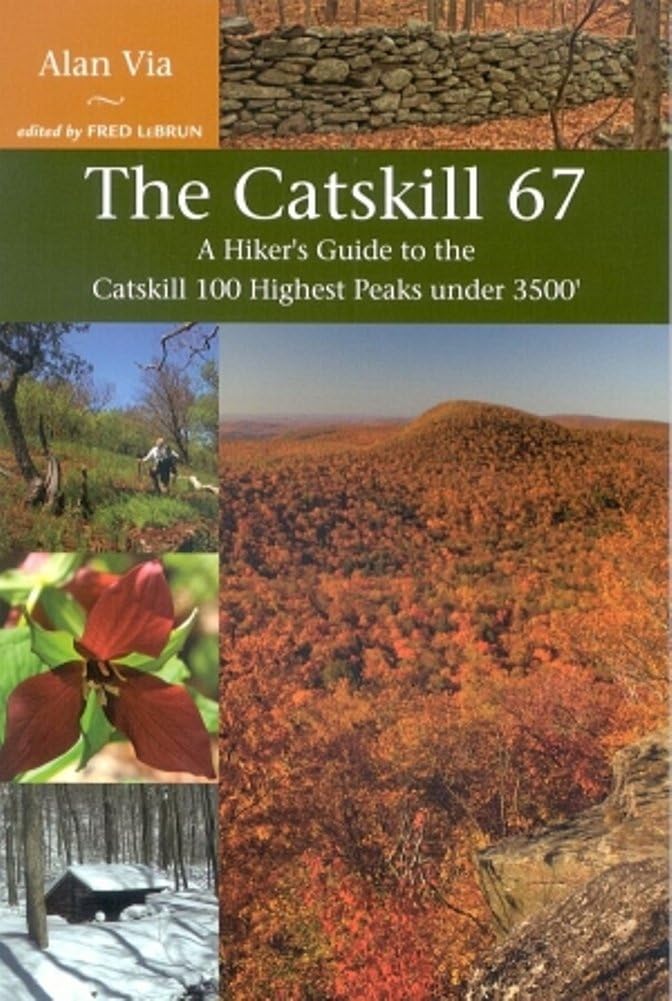
It s not often in this day and age an author gets to introduce a whole new group of mountains. Alan Via provides a wealth of information on a previously overlooked group of peaks: the Catskill 67. In this hiker s guide to the lesser-known peaks of the Catskill 100 Highest, Via provides routes to the summits on trails, woods roads, or bushwhacking with keen observations and a wry sense of humor. Complete with nine regional maps, a comprehensive peakfinder map that includes the Catskill 100 Highest, four-color images, and GPS coordinates for trailheads and difficult road intersections. Peaks are rated for difficulty, view, and bushwhacking potential. Review: This books is fantastic. So much great information - This books is fantastic. So much great information, solid maps and nice details. I used this book when I climbed the Catskill 67 and it proved to be a valuable resource. Alan Via includes lots of details about each mountain, and the wonderful nature and scenery found at each of them. I thoroughly enjoyed this book and I am sure any Catskill / hiking / outdoor enthusiast would as well. Review: Great guidebook except for one annoying omission - This attractive guidebook is well-organized with beautiful pictures and engaging descriptions of the trails. The author talks about the primary routes up each peak along with various alternate routes or combinations that can be done. Height, rank, view, difficulty, and interest ratings are all easily accessible. My biggest complaint is that finding the mileage and elevation gain for each hike described it not easy. There is no master list of listed hikes and mileage or even a line item in each entry of the mileage and elevation. I finally realized that this information is usually tucked somewhere in the narrative of the trail, but it is not obvious or easily accessible. Finding this for each hike takes considerable scanning. Even then you need to read carefully because some mileage is listed as one way while others are round trip. Looking for a short hike with low elevation gain that is kid-friendly takes some work. The book has a lot of great points and is still useful, I just don't quite understand why fairly standard element of hiking guidebooks was completely missed. If this goes into another edition, that would definitely improve its usability.
| Best Sellers Rank | #3,967,245 in Books ( See Top 100 in Books ) |
| Customer Reviews | 4.5 out of 5 stars 25 Reviews |
S**E
This books is fantastic. So much great information
This books is fantastic. So much great information, solid maps and nice details. I used this book when I climbed the Catskill 67 and it proved to be a valuable resource. Alan Via includes lots of details about each mountain, and the wonderful nature and scenery found at each of them. I thoroughly enjoyed this book and I am sure any Catskill / hiking / outdoor enthusiast would as well.
K**D
Great guidebook except for one annoying omission
This attractive guidebook is well-organized with beautiful pictures and engaging descriptions of the trails. The author talks about the primary routes up each peak along with various alternate routes or combinations that can be done. Height, rank, view, difficulty, and interest ratings are all easily accessible. My biggest complaint is that finding the mileage and elevation gain for each hike described it not easy. There is no master list of listed hikes and mileage or even a line item in each entry of the mileage and elevation. I finally realized that this information is usually tucked somewhere in the narrative of the trail, but it is not obvious or easily accessible. Finding this for each hike takes considerable scanning. Even then you need to read carefully because some mileage is listed as one way while others are round trip. Looking for a short hike with low elevation gain that is kid-friendly takes some work. The book has a lot of great points and is still useful, I just don't quite understand why fairly standard element of hiking guidebooks was completely missed. If this goes into another edition, that would definitely improve its usability.
R**N
An Excellent Hiking Guide for Exploring Lesser Known Catskill Peaks
For anyone who enjoys hiking in the Catskill Mountains of New York, or who thinks they might like to do so, there is an excellent new guidebook in town: The Catskill 67: A Hiker's Guide to the Catskill 100 Highest Peaks under 3500'. The author, Alan Via is an experienced Catskill hiker with strong first-hand knowledge of his subject. The book is clearly written, accurately researched, and easy to navigate. The index is easily searchable - so important for this kind of book. Maps and photos are found throughout. All of the above is what one might expect to find in a good guidebook, but there is more. There are nine maps, one for each geographical area. These are full-page topo maps and all in color. Each includes 100-foot contour lines, and indicates cities/towns, roads, trails, bodies of water, various roads (state, county, local, DEC-maintained), scenic trails, trail access parking when appropriate, scenic views, cemeteries, and fire towers. The maps also show whether the area is open to fishing, biking, paddling, swimming, cross-country skiing, camping, or picnicking. Finally, there is a valuable "Mapfinder" in the back pocket of the book, which shows the relationship of each region to the greater Catskill Park. Throughout the body of the book Via's writing style is clear, concise, and down-to-earth. Far from being a mere objective presentation of facts, one gets the feeling that an experienced guide is talking to you. Those who have hiked with the author know of his wry sense of humor, which shines through his writing and personalizes it nicely. The book contains a liberal number of photographs - all in color! - taken by several of Via's hiking companions. Each chapter includes a concise but thorough overview of each geographical area, as well as highlights and a summary of each of the peaks. Each peak is also given a score of 1 through 5 for view, interest, hiking difficulty, and difficulty of bushwhack. Admittedly these ratings are subjective but they are a good relative comparison of the peaks. It is important to note that many of "the 67" are either in part or entirely on private land. The section titled "Respect for the Mountains" tackles this sensitive topic head-on, encouraging the hiker to "do your homework" by seeking permission before walking on someone else's land, respecting the land when walked on, and avoiding such practices as marking routes along the way. The book does not indicate the location of summits, trails, and paths that fall on private land. All of these issues are broached throughout the book when necessary, not merely in this introductory chapter. The book also includes a numerical ranking of all Catskill peaks over 3500 ft. and a separate list of "the 67". Elevation is indicated, and the peaks are coded to indicate whether they have rough roads, ski areas, whether the peak has a trail, is unmaintained, or if it is a bushwhack. there is also a section titled "Before You Begin" in which Alan offers tips on GPS coordinates, hiking during hunting season, and bushwhacking. The book contains three appendices, a glossary of terms, references, and an index. In the first appendix, valuable tips on "Bushwhacking Basics" are offered, though Via is careful to point out that this is not a "how-to" book. "A Subjective Look at the Peaks" offers a short list of the "most, least, best, and scrappiest" peaks. The third appendix, "Tandem Peaks" suggests possible "two-fers" and even a couple of "three-fers" for hikers to grab multiple peaks in one day. The glossary entries are not mere one-sentence definitions, but valuable paragraphs of information. The "References and Suggested Reading" section includes books, maps, and websites, all of which are annotated. Finally, and perhaps most important, there is a thorough index that references many terms, persons, and peaks that may be easily found throughout the book. In summary, The Catskill 67: A hiker's guide to the catskill 100 Highest Peaks under 3500' is a welcomed addition to the array of guidebooks available today and deserves a place on the bookshelf of anyone who is interested in exploring the Catskills.
M**.
Alan Via's "Catskill 67" is for the hiker who has moved on to their next challenge.
This book is not for the casual hiker. The Catskill 3500 hikes are well documented, and most even had well-trenched herd paths when my wife and I finished in 2021. Alan Via's "Catskill 67" is for the hiker who has moved on to their next challenge. Yes, most of the remaining 102 peaks have bushwacks and are tougher than the 35ers. The author clearly describes the difficulties of bushwhacking and getting permission to hike on private property. This book helps one plan out their next hikes. The intent is for the reader to create their own lists, study their topographical maps, and see more of what the region offers by taking a deeper dive into the backwoods.
A**R
Introduction to the Catskills: hiker's need for hiking boots, sticks, start time to finish time.
The Catskills is a huge area. I like the way the book breaks down the areas into geographical chunks. I am using this book to help explore the Catskills - we hiked 3 mountains in 3 days. It was exhausting and exhilarating - a key about the difficulty and rating of the views was very useful. Included with the book is a very helpful color map, giving the reader a nice overview.
G**T
A great guide to little-down hikes
"The Catskill 67' describes the 67 mountains that make up the 100 highest peaks after the 35 that hikers do to get their 3500 patch (for those peaks over 3500'). 35+67=102 ... because the three smallest of the 67 are all the same height. Most guide books from ADK are pretty dry - they describe the trails and give you a ton of information, but they don't have much personality. Via's voice really shines through in this book - his enthusiasm for the woods is evident. Besides describing the trail, he also tells readers what types of flora and fauna they might see. Humorous asides are common. Via divides the mountains into nine different regions, each of which gets its own custom-made map. Each region also starts with a general description of the area and other activities that are possible there - places to fish or swim or cycle, for instance. Within each region, the mountains are listed in order of descending height. Then Via gives each mountain a rank (its order in height among the 67), a view rating, an interest rating, a difficulty rating and a bushwhack rating. What's really nice is that there's a chart at the beginning of the book listing all of the Catskill 100 highest that shows you whether they're trailed or not and which USGS map (or "Catskill 67' map) to find them on. So if you want to use this book to find little-known hikes in the Catskills but don't want to bushwhack, you can use this chart to narrow your options. Also new to ADK guidebooks - every page of the book is in full-color and it's sprinkled with photos by Via and some of his hiking companions. The back of the book includes several appendixes (including "Bushwhacking Basics," a breakdown of the peaks into categories like most challenging and easiest to bushwhack, a list of peaks that can be hiked in tandem, a glossary of terms and a list of references. It's a great book for anyone looking for new and interesting places to explore in the Catskills.
M**N
So many tempting destinations
Wonderful book that might be what it takes to guide this long lapsed hiker back into the woods. It received immediate promotion to first place in the rack next to the throne, a position from which it will not be easily dislodged. There is a density of content that belies its slenderness, and some items will never grow stale, such as the exhilarating View from Mt. Pisgah, the promised land.
J**N
Four Stars
Excellent guide book with accurate maps.
Trustpilot
3 weeks ago
1 week ago