We remain fully operational. Our teams are working around the clock to ensure your deliveries continue safely.

DOWNLOAD THE APP


Customer Services
Copyright © 2025 Desertcart Holdings Limited
DOWNLOAD THE APP


OS Explorer OL7: The Lake District, South-eastern area: OL07 (OS Explorer Map) : Ordnance Survey: desertcart.co.uk: Books Review: Mapping works of art, and well deserving of a five star rating! - These Ordnance Survey 1:25,000 scale Explorer maps are, in every sense, works of art! - They have “evolved” over the years since they were first introduced, and occasional minor changes to detailing and symbols etc. continue to this day. And these days, the mobile download bonus is a superb additional extra. As for ease of use “on the hill”, it has to be said that the paper maps can be somewhat cumbersome, as they cannot be opened to show every part of the map without fully unfolding – and in a howling gale that can be a very difficult process! – In that respect, the “ingenious foldability” and 100% waterproofing of Harvey Superwalker XT25 range is much superior. However, with the one exception that Public Rights of Way, (which may or may not exist at all as tracks on the ground), are shown much more prominently than paths that actually do exist on the ground, the mapping is truly superb. – Actual paths are shown as very small black dotted lines, whereas Public Rights of Way are shown much more boldly, as green hashed lines. I personally find that to be a major niggle! – When I’m out on the hills in dense mist, I want to know where the real world paths on the ground are – not where designated public rights of way are!!! – If anything, the actual paths on the ground should be shown more boldly than rights of way! Having said all that, especially when being viewed from the comfort of an armchair, there is nothing to beat the quality of Ordnance Survey mapping. In my humble opinion, still fully deserving of a five star rating here on desertcart! Review: Is an accurate map. - An OS map. Not much better for the purpose.


| Best Sellers Rank | 56,814 in Books ( See Top 100 in Books ) 363 in Walking (Books) 381 in Hiking (Books) 594 in Travel Atlases & Maps |
| Customer reviews | 4.8 4.8 out of 5 stars (706) |
| Dimensions | 13.4 x 2.7 x 24.1 cm |
| Edition | 2016-08 |
| ISBN-10 | 0319263339 |
| ISBN-13 | 978-0319263334 |
| Item weight | 130 g |
| Language | English |
| Print length | 1 pages |
| Publication date | 5 Sept. 2016 |
| Publisher | Ordnance Survey |
M**E
Mapping works of art, and well deserving of a five star rating!
These Ordnance Survey 1:25,000 scale Explorer maps are, in every sense, works of art! - They have “evolved” over the years since they were first introduced, and occasional minor changes to detailing and symbols etc. continue to this day. And these days, the mobile download bonus is a superb additional extra. As for ease of use “on the hill”, it has to be said that the paper maps can be somewhat cumbersome, as they cannot be opened to show every part of the map without fully unfolding – and in a howling gale that can be a very difficult process! – In that respect, the “ingenious foldability” and 100% waterproofing of Harvey Superwalker XT25 range is much superior. However, with the one exception that Public Rights of Way, (which may or may not exist at all as tracks on the ground), are shown much more prominently than paths that actually do exist on the ground, the mapping is truly superb. – Actual paths are shown as very small black dotted lines, whereas Public Rights of Way are shown much more boldly, as green hashed lines. I personally find that to be a major niggle! – When I’m out on the hills in dense mist, I want to know where the real world paths on the ground are – not where designated public rights of way are!!! – If anything, the actual paths on the ground should be shown more boldly than rights of way! Having said all that, especially when being viewed from the comfort of an armchair, there is nothing to beat the quality of Ordnance Survey mapping. In my humble opinion, still fully deserving of a five star rating here on Amazon!
M**H
Is an accurate map.
An OS map. Not much better for the purpose.
P**D
Excellent for explorers!
As a family of 6 we like to explore and get out walking. These are great maps and come fully recommended. I usually opt for the "active maps" which are laminated and thus water proof... but given that this came with an online code, I decided to research the route at home, then use the map on my phone whilst out on the walk. The online mapping system places a red arrow exactly where you are, so if you go off course, it's immediately obvious and you can change course saving time and energy. This enabled us to spend four days exploring every nook and cranny around Arnside and Silverdale. Money very well spent. Bargain.
J**H
A great printed map.
This OL map covers about twice the terrain the original versions did. Contains all of the great map work we expect from Ordnance Survey. 2 cons, double sided so you can end up flipping the map over at times and not waterproof, although the paper does feel slightly shiny. Also the downloadable version requires subscription, about £30 per year, £3 per month, which is not clear until you've downloaded the software & entered the unique map number. This is slightly annoying considering the price of the map.
M**M
Great map!
Great map helped us around the Lake District. I would definitely recommend.
O**G
Great, but prefer the Landranger series.
OS maps are awesome. Having lived in countries where such things don't exist I appreciate what they offer. Scale is good and larger than the Landranger. The legend is different from Landranger series so can take a while to get used to. If this is what you like, go for it. OS do an amazing job.
M**.
Great price, esp as it includes a digital download.
Fabulous price, includes digital download for your phone…. Which is actually more helpful than the map itself, especially as you can transfer it to another device if needed.
R**N
Best maps ever.
You can't go wrong with OS Explorer maps. I own most of them for the Lake District area. They will show you paths you'd never know existed. And also: You won't get lost and end up crying for help over the phone. Believe me, Mountain Rescue have better things to do than taking tourists home ;)
H**E
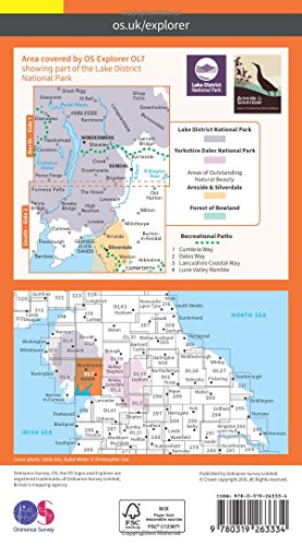
When hiking and exploring in the Lake District, it helps to have a good map. This two-sided Ordnance Survey Explorer map covers the southeast quadrant of Britain's most popular national park, from Grasmere to Kendal on one side, and from the bottom of Windermere to the Irish Sea and Silverdale outside the park on the other. Coverage includes Grasmere, Windermere and Coniston. The scale is a very user-friendly 1:25,000, with easy-to-read graphics, and a mobile download. The map cover is plasticized. The map itself is paper and needs protection from the famously wet weathers in the Lake District. Highly recommended.
Trustpilot
1 month ago
1 week ago